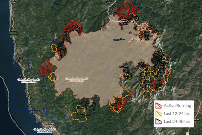
Monday, September 4th, 2017 began with significant advancement on all fronts of the Chetco Bar Fire. Many residences were awoken in the early morning and warned of rapid advancement, especially in the Southbank Chetco Road and Winchuck drainage areas. With no acreage increases reported due to a lack of infra-red fly overs on Sunday, Monday evenings acreage increases showed enormous growth of 24,926 acres. Crews also lost half of its containment, which left the massive 162,513-acre blaze only 5% contained.
A strong north wind through out Sunday evening and Monday morning fanned extreme group torching, spotting and short crown runs.
In the south west area, Mt. Emily and spots into Mill Creek within a mile or so above the Chetco River, saw considerable advancement during an early morning run.
The North West corner of the fire spread steadily to the north and west, with widespread backing and flanking. Flanking is when parts of a fire’s spread advance to the sides then run roughly parallel to the main direction of spread. Separated flank heads are extremely dangerous in steep terrain.
There was also a large run into the Biscuit Fire scar of about 4.5 miles to the south and east on the east end of the fire. In this area, a variety of fuels such as tan oak, canyon oak and dense brush fields of manzanita and ceanothus helped sustain rapid growth. The older fire scars contain numerous snags and heavy dead and downed timber. Dry Oak leaf litter supported active surface fire spread. Areas within the harvested cut blocks have heavy slash fuels and large piles which burned intensely.
This extreme activity from Sunday afternoon and evening, continuing through out Monday, brought two new evacuation notices Monday.
The first occurred when the US Forest Service closed Illinois River Road and began turning back public traffic along the Illinois River Road. At approximately 10:30 AM the Chetco Bar Fire Incident Commander together with the Josephine County Sheriff’s Office and the Illinois Valley Fire District, issued a Level 3 evacuation order for all residents on Illinois River Road within the US Forest Service Boundaries. This included the Oak Flat Community.
That evacuation was followed by yet another at approximately 6:00 PM, when the Chetco Bar Incident Management Team and the Curry County Sheriff’s Office expanded the area previously at a Level 2 Evacuation Order to a Level 3 Evacuation Order which included all areas along Carpenterville Road north of the Cape Ferrelo Road intersection to the Carpenterville Road and Bosley Butte Road intersection.
On Tuesday, the 1600 firefighters will continue suppression efforts to slow or stop fire spread from entering the Winchuck drainage and structure protection is expected to continue to be required.
Crews will attempt to re-establish old Biscuit fire dozer lines, and continue new line construction. As they build direct and indirect lines where possible, they will also continue to improve roads for future containment spread to the North-Northeast into Oak Flat, Store Gultch, McCaleb’s Ranch, and Footbridge.
Aircraft will be utilized to check fire spread when possible.
Curry County Sheriff and Josephine County officials will continue to monitor evacuation levels while the Oregon State Fire Marshal Task Force continues structure evaluation and preparation.
As of this update, all previous evacuation levels remain unchanged and intact. This includes a Level 3 evacuation order for all residents on Illinois River Road within the US Forest Service Boundaries and the Oak Flat Community.
The Level 3 Evacuation Order which included all areas along Carpenterville Road north of the Cape Ferrelo Road intersection to the Carpenterville Road and Bosley Butte Road intersection.
Thursday evenings expanded Level 2 Evacuation Order which included all areas along Winchuck River Road east of, and including Peavine Ridge Road.
An additional emergency evacuation shelter has been prepared for displaced residents at the Nazarene Church located at 1600 Chetco Avenue, Brookings, Or. (541)-600-6068.
The Tolowa Dee-ni’ Nation is now operating a shelter at The Xaa-wan’-k’wvt Village & Resort (old Ship Ashore) RV Park located at 12370 Highway 101 North in Smith River.
In the Gold Beach area, the Red Cross has moved its emergency evacuation shelter from the Riley Creek Elementary school in Gold Beach TO THE CURRY COUNTY FAIRGROUNDS SHOWCASE BUILDING AT 29392 ELLENSBURG AVENUE.
Residents are encouraged to monitor the interactive evacuation map for changes: http://arcg.is/2vWQN2N


