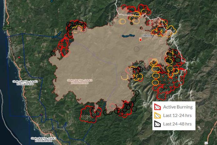
As of Monday morning the Chetco Bar Fire update for September 4th, 2017, followed another very hot day with temperatures in the upper 90’s up and down the coast. There was dense thick smoke lingering at ground level in the Crescent City, Gold Beach and Brookings areas, however, the smokey conditions did lift in the Brookings area in the afternoon.
At this time, no updated information on growth has officially been released, as infrared fly overs used to measure this data did not occur Sunday, September 3rd, 2017 due to extremely smokey conditions. However, Monday morning has eyewitness reports from the Mt. Emily area reporting that fire is now visible, and the Curry County Sheriff has acknowledged that residences on the upper areas of South Bank Chetco Road and the upper most parts of the Winchuck River and Pistol River areas are currently being threatened.
An excessive heat warning remains in effect through today after exceptionally dry conditions were observed on the fire yesterday afternoon. This is the fourth day that temperatures, humidity levels, and fuel moisture have aligned to create critical burning conditions with unstable air favoring active fire behavior. Increased winds predicted for today could result in an uptick in fire behavior and have the potential to carry embers close to half a mile. Smoke column development is possible especially on the east side of the fire in brush fuels.
Sunday, September 3rd showed very active fire behavior in several areas around the fire perimeter. On the eastern flank, a significant smoke column developed to a height of 23,000 feet in the early afternoon to the south. High temperatures and critically low humidity contributed to the increase in fire behavior and shifting winds in the afternoon improved visibility allowing aircraft to support ground operations with water drops on portions of the fire. Crews continued to connect roads, dozer lines and hand lines to form direct and indirect containment lines.
Firefighters will continue installing sprinkler systems and clearing brush to protect structures in Oak Flats in Josephine County and to the north toward Agness. Crews will seek out and extinguish sources of heat near the containment line (mop-up), and deploy hose along the fire perimeter to be used as fire containment lines or to aid in burnout or mop-up operations.
The fire became established in the Wheeler Creek drainage, and crews will focus on the southwest flank of the fire between Emily Creek and the Winchuck area as north winds push the fire southwest toward containment lines. Crews will continue working to slow the fire spread from the Winchuck drainage.
The forecasted northerly wind shift will drift smoke south again impacting Brookings, Cave Junction and Crescent City regions to the south. Communities to the north and west, such as Gold Beach, are expected to see improving air conditions. This may give aviation further opportunities to engage the fire. Conversely, those same winds can also increase or cause erratic fire activity.
Curry County Sheriff and Josephine County officials will continue to monitor evacuation levels while the Oregon State Fire Marshal Task Force continues structure evaluation and preparation.
As of this update, all previous evacuation levels remain unchanged and intact. This includes Thursday evenings additional 2,130 residences affected by the Curry County Sheriff’s Office 9:30 PM expanded Level 2 Evacuation Order which included all areas along Winchuck River Road east of, and including, Peavine Ridge Road.
The Tolowa Dee-ni’ Nation is now operating a shelter at The Xaa-wan’-k’wvt Village & Resort (old Ship Ashore) RV Park located at 12370 Highway 101 North in Smith River.
In the Gold Beach area, the Red Cross has moved its emergency evacuation shelter from the Riley Creek Elementary school in Gold Beach TO THE CURRY COUNTY FAIRGROUNDS SHOWCASE BUILDING AT 29392 ELLENSBURG AVENUE.
Residents are encouraged to monitor the interactive evacuation map for changes: http://arcg.is/2vWQN2N
·Note: There was no infrared flight last night. Data from these flights is used in verifying fire perimeter and calculating acres burned. Therefore, acreage is an estimate.


