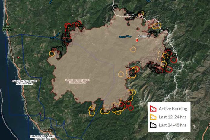
Saturday’s Chetco Bar Fire update, September 2nd, 2017, was a hot day with temperatures in the upper 80’s and 90’s up and down the coast, with even denser thick smoke lingering at ground level. Chetco Effect Winds added slightly less growth than the 7,045 acres on Friday by burning another 4,735 acres, bringing the total estimated acreage to over 142,587 acres. 1,629 firefighters again relentlessly fought very difficult conditions to maintain the 10% containment lines throughout the day.
Saturday’s most active area was in Upper Pistol drainage. Additional areas on the East flank within Biscuit scar developed a plume early in the day. Problems with torching and spots in south, northwest, and north continued throughout the day on Saturday. There are more than 8 hot areas around the 186+ mile perimeter.
Saturday also had two evacuation situations.
- The first was at 10:00 a.m. Saturday morning when the Josephine County Sheriff issued a Level 1 evacuation for Oak Flats, east of the Chetco Bar Fire. Residents were to be aware of the danger that existed in their area, monitor emergency service websites and local media outlets for information. Residents were told that this is a time for preparation and precautionary movement of persons with special needs, mobile property and (under certain circumstances) pets and livestock.
- The second evacuation situation was when Curry County Sheriff’s Office, at 11:00 AM, Saturday, September 2nd, 2017, reduced the area of Mountain Drive off of the North Bank of the Chetco River Road currently under a Level 3 Evacuation to a Level 2. Based upon current fire behavior, availability of resources and in coordination with the Chetco Bar Incident Management Team, all of Mountain Drive including Van Pelt Drive, Thomas Lane, Canyon Drive, E. Cougar Drive, and W. Cougar Drive are now within the Level 2 Evacuation level.
All residences and businesses within this current Evacuation zone previously described will be allowed to return. Residents that live in this geographic area are asked to present their picture identification to Curry County Sherriff’s Office Staff to receive re-entry materials. Residents must pick up the re-entry materials from 11 am to 2 pm at Ray’s Market 906 Chetco Ave in Brookings, Oregon. One re-entry point is established at Da-Tone Rock on the North Bank Chetco River Road. Residents will present the materials they received at Rays Market from the Sheriff’s Office at the established re-entry point.
On Sunday, September 3rd, extreme fire behavior is expected with poor relative humidity recovery rates. Torching, crowning runs, spotting to half a mile, and a high Haines Index of 6, will create the potential for large fire growth. There is also the possibility of plume and thunderstorm development.
An excessive heat warning remains in effect through 11 pm Monday night. A cooler weather system slightly east of the fire perimeter moving slowly eastward over the next couple of days is expected to lower the forecasted temperatures a couple degrees each day with relative humidity recovering slightly through early next week.
Winds will be a concern through Sunday. A weak flow at the surface and aloft will struggle to ventilate lingering smoke. Officials expect improved ventilation beginning Monday as moisture begins returning to the area.
Today, crews will continue to prepare and improve roads for future containment spread to the North-Northeast as the perimeter is encroaching on the wilderness boundary. They will also be creating direct and indirect lines to the North and East.
Fire officials will be attempting to locate and identify structures at risk in Oak Flat, Store Gulch, McCaleb’s Ranch, and Footbridge throughout the day. Heavy equipment and other local Forest Service and Oregon Department of Forestry resources will develop a plan for containment of the fire east of the Kalmiopsis Wilderness while scouting the Illinois River area to identify opportunities to open previous lines from previous fires in the area.
To sign up for evacuation alerts for your area of Josephine County, via the Josephine County Alert (Reverse 911) http://tinyurl.com/Josephine-County-Citizen-Alert
Residents should remain prepared to evacuate at a moment’s notice in the event the evacuation levels change and residents should not return any large animal’s home at this time.
Curry County Sheriff and Josephine County officials will continue to monitor evacuation levels while the Oregon State Fire Marshal Task Force continues structure evaluation and preparation.
Fire Officials have announced early Saturday that they will be conducting a Community Fire Briefing Sunday evening in Cave Junction, Oregon. Fire managers and other local officials will be updating the Chetco Bar Fire situation in Cave Junction, Oregon at the Illinois Valley High School, Sunday, September 3, 2017, at 7:00 p.m. The Illinois Valley High School is located at 625 East River Street in Cave Junction, Oregon 97523.
In the Gold Beach area, the Red Cross has moved its emergency evacuation shelter from the Riley Creek Elementary school in Gold Beach TO THE CURRY COUNTY FAIRGROUNDS SHOWCASE BUILDING AT 29392 ELLENSBURG AVENUE.
Residents are encouraged to monitor the interactive evacuation map for changes: http://arcg.is/2vWQN2N


