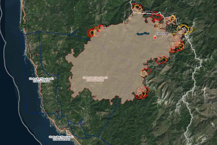
The Wednesday, August 30th, 2017, the Chetco Bar Fire update was a brief breath of fresh air. As of approximately 9:30 PM Wednesday evening, the Chetco Bar Fire had blackened over 128,758 acres, showing a significantly slower growth of 3,487 acres on Wednesday, and reportedly remains at 5% contained.
The fire was active on the north, south and east perimeter. It pushed several miles to the northeast into the area previously burned by the 2002 Biscuit Fire. Gold Basin Butte in the old Biscuit scar was the most active area to the east with moderate uphill runs and single tree torching,
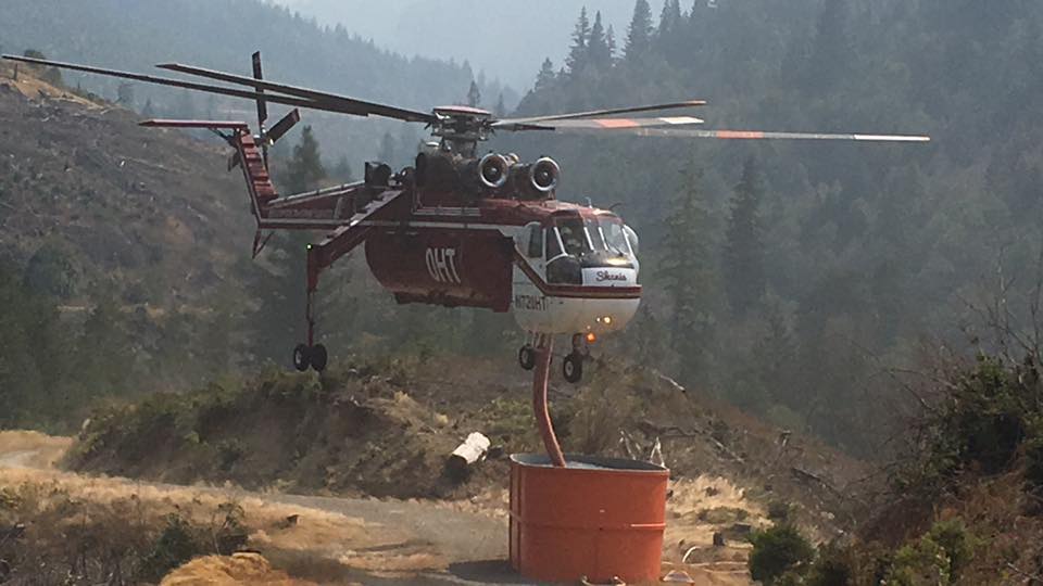
With improved visibility, each of the seven helicopters assigned to Chetco Bar was able to work the fire on Tuesday. On the southern flank, aircraft provided bucket drops in the Emily Creek area. Crews connected most of the contingency line on the southwest/west edge and have been searching for, and extinguishing, hot spots within 25 feet of the fireline. Indirect line construction occurred in the Pistol River area. Over the course of the incident, Oregon State Fire Marshal crews have assessed 1,222 structures, completed preparation work on 532 structures, and set more than 500 sprinklers.
On Wednesday, National Guard firefighters joined the effort. These men and women have been tasked with extinguishing hot spots that could potentially threaten containment lines between the fire and Brookings. Firefighters will take advantage of the moderated fire behavior early in the day to construct lines in advance of the coming weather. This effort includes fireline construction in the areas at risk near Emily Creek and Hog Mountain. Aircraft will assist crews on the ground as visibility permits.
High pressure is building into the Pacific Northwest, while thermal low pressure lingers over Northern California. This set the stage for strong and gusty Northeast winds Wednesday night into Thursday. Rapid drying is expected Thursday into Thursday night. Chetco Effect winds are expected to continue into Thursday night and Friday morning while relative humidity falls to very low levels. This will be followed by a prolonged hot and dry spell, with several nights of poor humidity recovery likely for all but the lowest elevations of the fire. Fog is predicted to develop overnight and is expected to cover most of the lower elevations of the fire Thursday morning. The resulting cooler temperatures and improved humidity recovery should moderate fire behavior.
Later Thursday officials expect a strong high-pressure front will move into the area. The resulting rise in temperatures, coupled with lower humidity and drying winds will increase fire activity. The fire could make its way to the tops of individual or groups of trees and potentially cast embers up to three-tenths of a mile, causing new ignitions (or spot fires). Temperatures will continue to rise this week and increases in fire behavior are anticipated.
The approximately 1427 personnel fighting the widespread fire area continue building and reinforcing direct and indirect containment lines with direct dozer lines and hand lines. Continued structure protection efforts, hose laying, removal of flammable materials and road improvements for fire lines were just some of the efforts performed by fire crews over the past few days. Scouting areas for new containment lines have been performed by fire crews over the past few days.
Officials continue to coordinate with the local Forest Service and Oregon Department of Forestry resources to develop a plan for containment of the fire east of the Kalmiopsis Wilderness while maintaining current coordination with Curry County Sheriff regarding evacuation levels.
All evacuation levels remain unchanged and intact.
Displaced residents may relocate to an emergency evacuation shelter at Riley Creek Elementary in Gold Beach 94350 6th St. Gold Beach, OR. (541)-600-6068. Travelers in campers and motels are asked to relocate elsewhere along the Oregon coast. Residents should make arrangements to move property and livestock. People with special health needs or other concerns should relocate during the warning.


