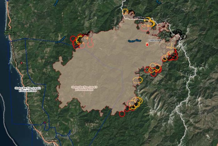
Thursday, August 31st, 2017, the Chetco Bar Fire update began with a new level 2 evacuation notice at approximately 10:00 PM in the Winchuck River area. The Chetco Bar Fire had blackened over 131,197 acres as of 10:00 PM Thursday night, showed slower growth of 2,500 acres and is now 10% contained.
A very active day is now affecting fire protection districts located in Pistol River, Brookings, Harbor, Cape Ferrelo, and Winchuck prompting A NEW LEVEL 2 EVACUATION NOTICE AT APPROXIMATELY 10:00 PM THAT HAS BEEN ORDERED BY THE CURRY COUNTY SHERIFF’S OFFICE AND HAS EXPANDED TO INCLUDE ALL AREAS ALONG WINCHUCK RIVER ROAD EAST OF AND INCLUDING PEAVINE RIDGE.
THE BROOKINGS POLICE DEPARTMENT AND THE OREGON STATE POLICE ARE ASSISTING THE CURRY COUNTY SHERIFF’S OFFICE WITH MAKING NOTIFICATIONS TO ALL AFFECTED RESIDENTS WITHIN THE NEWLY IDENTIFIED EVACUATION AREAS.
The Tolowa Dee-ni’ Nation is now operating a shelter at The Xaa-wan’-k’wvt Village & Resort (old Ship Ashore) RV Park located at 12370 Highway 101 North in Smith River.
Residents are encouraged to monitor the interactive evacuation map for changes: http://arcg.is/2vWQN2N
The weekend weather forecast indicates critical fire weather and the potential for extreme fire behavior. Gusty, offshore winds will continue Thursday night and Friday morning while relative humidity falls to very low levels. This will be followed by a prolonged hot and dry spell with poor relative humidity recovery. Winds have the potential to carry embers seven-tenths of a mile.
Red Flag Warnings are in effect for the Chetco Bar Fire area through Friday evening for strong, gusty, northeast winds and low relative humidity through Friday morning, followed by very hot, dry and unstable conditions Friday afternoon and evening. Gusty offshore Chetco Effect winds will likely peak into tonight and Friday while relative humidity levels fall to very low levels. Winds will ease later Friday as thermal low pressure drifts onshore.
As winds ease later Friday, a thermal low-pressure system will present new problems on Friday and Saturday. The weekend is expected to be extremely hot, dry and unstable with mid-level Haines 6 conditions. The “Haines Index” also known as Lower Atmosphere Severity Index measures the potential for dry, unstable air that contributes to the development of large or erratic wild land fires. Hot and dry weather will continue Sunday and Monday, though shallow onshore flow will gradually moderate relative humidity levels.
Officials are preparing for the possibility of significant perimeter growth and smoke column development is possible.
Task forces from the Oregon State Fire Marshal will continue assessing structures in the Winchuck and Pistol River areas; preparing them for the possibility of the fire being pushed into the area by the coming winds.
Thursday had several areas active on the north, south, and east perimeter. The most active area was a late day mile long run in brush and timber up the south face of the Tincup Creek drainage. The fire pushed eastward toward the Kalmiopsis Wilderness boundary into brushy vegetation north of Pearsoll Peak, in a portion of the area previously burned during the 2002 Biscuit Fire.
The favorable visibility provided opportunities for aerial support as firefighters completed significant work along the northwest and south flanks of the fire. Crews connected old dozer lines and strengthened fire lines directly along the perimeter of the west flank.
South of the fire, crews will work on constructing alternate lines and tying in the section where fire crossed Emily Creek. On the northwest perimeter, crews will bring lines north to steer fire north and east. To reduce travel time, a contingent of firefighters will work from a remote camp near Agness. On the eastern flank, firefighters are looking for opportunities to use fire line previously constructed during the 2002 Biscuit Fire while assessing structures along the Illinois River just east of the Wilderness.
All previous evacuation levels remain unchanged and intact at this time.
In the Gold Beach area, the Red Cross is moving its emergency evacuation shelter at Riley Creek Elementary in Gold Beach TO THE CURRY COUNTY FAIRGROUNDS SHOWCASE BUILDING AT 29392 ELLENSBURG AVENUE.


