The Chetco Bar Fire slowed considerably over the past 24 hours with only 60 acres of growth over the whole fire. Aerial observers report the most activity and smoke in the northern parts of the fire with minimal fire activity on the eastern flank. Overnight relative humidity did not drop as low as expected, keeping morning fire activity minimal. The fire now stands at 182,340 acres and 5% containment.
With temperatures rising and relative humidity levels decreasing, an increase in fire behavior is expected today across southwest Oregon. Smoke production is expected to increase today with moderate fire behavior. Winds from the north and northeast will push smoke toward coastal areas including Gold Beach, Brookings and further south into northern California. Highway 101 may see reduced visibility in some areas. Periods of unhealthy air may be experienced in coastal towns by this afternoon /evening. Inland, in the Cave Junction, Grants Pass, Medford and other Rogue Valley communities, moderate conditions this morning are expected to worsen through out the day, possibly reaching unhealthy levels for periods of time. This is due to smoke from several regional fires impacting this zone.
Fire crews continue to make progress tying together long sections of old Biscuit Fire dozer-built containment lines between the fire and Highway 199, totaling approximately 50 miles of completed fire line. Hand line work has progressed in steep rocky terrain between Josephine Creek and Parker Creek. Firelines have been extended in the Silver Creek area on the northeast side of the fire. Work using masticating equipment to clear vegetation along Illinois River Road is nearly complete. Structure protection work, like brush removal and improving road access, has been completed around the communication sites at Eight Dollar Mountain.
Today, temperatures are expected to reach a high point for the week at around 90-95 degrees with minimum relative humidity in the teens. Winds are forecast at 5-10 mph and will be out of the northeast. These conditions along with drying fuels will likely influence more active fire behavior than yesterday, with the possibility of short uphill runs if fuel conditions allow. Tomorrow is expected to be cooler than today.
Hand crews will continue work today closing small gaps in the fire lines on the eastern flank around Parker Creek headwaters, Tennessee Mountain, and Josephine Creek. Masticator equipment will remove roadside vegetation in the Rough and Ready Flat area and to the south. Dozers will continue pushing to the north, reopening fire lines from the 2002 Biscuit Fire. Initial attack crews will respond to new starts and spot fires.
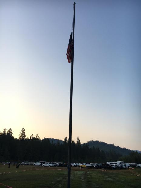
This morning, Oregon National Guard members, including the 162nd Infantry Regiment based in Springfield, Oregon, honored the 16th anniversary of September 11, 2001 at the Lake Selmac fire camp. The members raised the American flag to full staff and solemnly lowered it back to half-staff.

The 162nd Infantry Regiment is based in Springfield, Oregon and was mobilized to assist with the Chetco Bar fire by Oregon Governor Kate Brown.
Curry County Sheriff and Josephine County officials will continue to monitor evacuation levels while the Oregon State Fire Marshal Task Force continues structure evaluation and preparation.
As of this update, all previous evacuation levels remain unchanged and intact. This includes a Level 3 evacuation order for all residents on Illinois River Road within the US Forest Service Boundaries and the Oak Flat Community.
The Chetco Bar Incident Management Team, and Curry County Sheriff have reduced some Level 3 Evacuation areas to Level 2 Evacuation’s within Curry County. Only residents and land owners are allowed to enter the previous Level 3 Evacuation Areas.
These Areas include:
• Pistol River Road
• Carpenterville Road
• North Bank Chetco River Road to the established fire perimeter
• Gardner Ridge Road to the established fire perimeter
• South Bank Chetco River Road
Residents must pick up the re-entry materials from 11 am to 4 pm at Ray’s Market 906 Chetco Ave in Brookings, Oregon. All residents that live in these geographic areas are asked to present their picture ID to Curry County Sheriff’s Office Staff to receive re-entry materials. Residents and land owners will need to present the materials received from the Sheriff’s Office at their established re-entry point.
Residents should remain prepared to evacuate at a moment’s notice in the event the evacuation levels change and residents should not return any large animal’s home at this time. Fire and emergency resources will continue to be active in the areas and road systems. Please drive slowly and be aware of additional traffic in the Level 2 Evacuation area.
The Tolowa Dee-ni’ Nation is now operating a shelter at The Xaa-wan’-k’wvt Village & Resort (old Ship Ashore) RV Park located at 12370 Highway 101 North in Smith River.
Residents are encouraged to monitor the interactive evacuation map for changes: http://arcg.is/2vWQN2N


